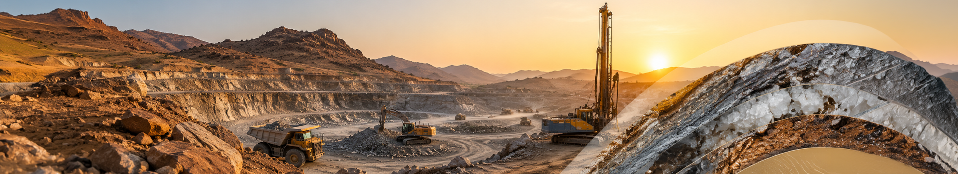
Department of Mines & Geology order on Amaldaramad of Mining Lease – In land terminology, Amaldaramad refers to the mutation or formal entry of a new lease or ownership right into official revenue records. When applied to mining descriptions under the Department of Mines and Geology (DMG), this procedure updates the local khasra (land plot) maps to reflect encumbrance or usage rights.
Key Requirements for Amaldaramad:
-
- Approved Mining Lease/Grant Order: You must have the official sanction order for the mining lease issued by the DMG.
- Demarcation Report: A formal survey and demarcation of the mining area conducted by the concerned Mining Engineer.
- Revenue Maps (Tatima): Updated tracings of the land showing exactly which khasra numbers overlap with the sanctioned mining zone.
The Procedural Steps:
-
- Application: Submit an application to the local Tehsildar or Sub-Divisional Magistrate (SDM), along with the verified Mining Plan, lease execution documents, and the DMG grant order.
- Verification & NOC: The revenue office cross-checks the boundaries with adjacent landowners and ensures no public disputes or forest land regulations are violated.
- Mutation Order: Once verified, the Tehsildar issues the Parwana Amaldaramad.
- Record Update: The land records (e.g., Jamabandi or Khatauni) are officially endorsed with the mining description, legally recognizing the mining rights on that specific plot.
Department of Mines & Geology order on reform plotting 2017/24 – Demarcation of a mining lease is the process of physically marking and legally defining the exact geographical boundaries of a designated mining area. It utilizes modern GPS/GNSS coordinates to prevent overlapping leases, protect restricted zones, and ensure miners strictly operate within their legally permitted boundaries.
The Demarcation Process:
The process of establishing and verifying lease boundaries involves several key steps:
-
- Delineation: Before a lease or quarry license is granted, the state government delineates the area using satellite-based systems (GPS/GNSS) or exact survey measurements.
- Survey & Verification: Authorized state mines or revenue officials conduct a physical survey of the perimeter using fixed reference points.
- Pillar Erection: Once approved, the leaseholder must establish and permanently maintain boundary pillars. In locations like Rajasthan, for example, these pillars must be at least one meter high with a yellow-painted finish, prominently displaying the lease and pillar numbers in black paint.
- Digitization: All demarcated points, buffer zones, and broken-up areas (like dump yards and processing plants) are captured via Total Station (TS) surveys and recorded on the area’s official map
On Representation of Federation, DMG issued an order for correction of discrepancies in demarcation of mining leases in online master map of DMG Portal.
On Representation of Federation, DMG inserted a new Rule for Resolution of discrepancies in survey, demarcation and record keeping in Rajasthan Minor Mineral Concession (Amendment) Rules, 2025.
Drone Survey of Mining Leases- Following the Rajasthan Minor Mineral Concession Rules amendment, mining leaseholders in Rajasthan are required to conduct annual drone surveys. Surveys must cover the entire leased area plus a 100-meter buffer zone, and be submitted along with Digital Elevation Models (DEM) and orthomosaic images.
Rajasthan’s Mines Department mandates that all mineral-transport vehicles (such as tippers, dumpers, and trucks) are equipped with AIS-140 compliant Vehicle Tracking Systems (VTS). This infrastructure integrates with digital e-rawanna passes and automated weighbridges to prevent route deviation, overcharging, and illegal mining operations.
Mandatory Vehicle Tracking Requirements:
-
- Device Compliance: Vehicles must utilize AIS-140 certified Vehicle Location Tracking Devices (VLTD) that are approved by the Rajasthan Transport Department and the Department of Mines & Geology (DMG).
- Real-Time Monitoring: Approved devices feature geofencing and emergency alerts, allowing the state to track transport routes and ensure vehicles are not deviating from designated paths.
- Automated Transit: Weighbridges are linked directly to tracking systems so transit gates and toll barriers only open for authorized, properly weighed, and electronically tracked vehicles
Standard Operating Procedure (SOP) for Procurement and Installation of Weighbridge Automation Device by Vehicle Owners from Empaneled Vendors.
The purpose of this SOP is to provide a clear process for Weighbridge Owners to buy and install approved automation devices only through empaneled vendors, as per the Department of Rajasthan Mines guidelines. This ensures transparency, compliance with rules, accurate weighing, real-time data sharing, and better monitoring of mineral transportation.